Before we left on our journey we made a list of stopping
points.
 |
| Lovely Idaho |
The list included national parks we hadn’t been to, cities with famous
landmarks, family, and friends. It also included Idaho. Not a special place or
specific location, just Idaho. It was somewhere we both wanted to spend time
but we weren’t sure where to go or what to do. We asked for suggestions from
some friends who had lived there or visited before and came up with a general
plan for moving through the state. Our image of Idaho before the trip was
mountains, forests, and wild rivers. And potatoes. Because who doesn’t
associate Idaho with potatoes?
After leaving Glacier National Park (July 18), we went to
Kalispell for groceries, fuel, and Internet so we could make rare contact with
the outside world. It had been rainy most of the week in Glacier, but the
weather turned sunny and warm as soon as we drove away from the mountains. We
learned later that a wildfire started in Glacier a week after we were there and
closed down the western half of the Going to the Sun road. We’ve been fortunate
avoiding the national disasters so far!
 |
| Campsite friend |
South of Kalispell, we found a newly remodeled Flathead
National Forest campground on Swan Lake, a large actively used lake surrounded
by mountains. When we arrived, a sign announced that the campground was filled.
We talked to the camp hosts to see if there were any other alternatives, and
they told us there happened to be one site left… a giant, asphalt-paved double
vehicle campsite. It was funny to see our little Burro in a campsite made for a
massive RV! After a swim in Swan Lake, across the road from the campground, Walden
saw something black and slimy on his leg and asked Jim, “What is that?” Usually
it’s just a piece of seaweed that he freaks out about. But this time, it was
Walden’s first experience with a leech!
 |
| Feasting on huckleberries at Seeley Lake |
The next day (July 19), we continued south to Seeley Lake,
MT where we found a farmer’s market which excited Walden and me. We got to
sample Flathead Cherries and buy some fresh produce and locally made lavender
lotion. We found a campsite at the popular Seeley Lake campground (Lolo
National Forest) after being chased away from another campground by an
abundance of mosquitos. The forest surrounding our campsite was filled with ripe
huckleberries. Walden was in heaven… they have become one of his favorite
treats. Every time we turned around, we found him plopped down in the bushes eating
huckleberries until his hands and mouth were purple, ignoring the mosquitoes
biting his face. It was hot so we played in the sand and water daily. Seeley
Lake is a popular recreation area, and Walden had fun watching the motor boats,
water skiers, and jet skis plying the waters. We even enjoyed hot showers from
our shower bag two nights in a row.
 |
| Refreshing campsite shower |
 |
Master sandcastle builders
|
 |
| Morrell Falls |
On June 20, we took a day trip into Lolo National Forest.
We hiked a hot trail to the beautiful Morrell Falls (5 miles), a 90-foot
cascade that tumbles over black rock steps. The bottom of the falls was much
cooler in temperature providing a respite from the hot, dry hike.
We also took
a scenic drive on the Clearwater Loop Road, which provided beautiful views of
the Swan Mountain range and a short trail to the pristine, undeveloped Clearwater
Lake. The lake was crystal clear and looked much like northern Minnesota with
the addition of mountains in the background. We heard at least four loons
calling and displaying their mating behaviors, and saw one mother with a young
chick. We enjoyed the experience immensely and were amazed to learn that there
are only 60 mating pair of loons in Montana and only 30% of the young survive.
|
|
Walden found a frog in Clearwater Lake
|
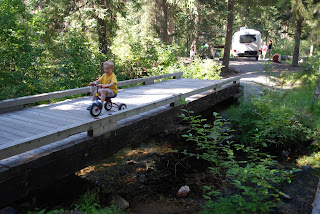 |
| Crossing the bridge into our campsite |
On July 21, we stopped in Missoula for Internet and other
necessities. We were happy to find free wireless at a local mall with a play
area, air conditioning, and lots of room for parking the Burro. I suspect this
is where Walden picked up a bug that led to a cold that he and I are both still
fighting. Darn civilization. That evening, we started driving up to Lolo Pass,
which crosses from Montana into Idaho. This is the same route that Lewis and
Clark took both on their way west and their return home. We camped at Lee Creek
(Lolo National Forest) just east of Lolo Pass. We loved that our campsite had
its own bridge over a creek, an interpretive trail adjacent to the campground,
and several large boulders to climb.
 |
| Lewis and Clark picked a great campsite |
The next morning (July 22), we continued our journey to
Lolo Pass, stopped at a quaint visitor center, and hiked to see Glade Creek
Camp in a nearby meadow, one of the many campsites Lewis and Clark used.
As we
drove west along Highway 12, we were immersed in the Idaho of our imaginations.
Steep mountains covered in pointed conifers hugged both sides of the road and
the Lochsa River tumbles over boulders cutting through the valley.
 |
| Soaking in a warm pool (Walden didn't like the hot ones) |
We stopped at Warm Springs (Clearwater National Forest),
one of the many hot springs in Idaho. After crossing an amazing swinging bridge
over the river we came to a forest service sign stating that this was a “CLOTHING
OPTIONAL AREA. You may encounter nude hikers along this trail and its terminus
point.” Cool! The official U.S. Forest Service logo really made the laminated
sign funny. We hiked through a beautiful forest (2 miles) and found the heated
water oozing from a hillside and filling small pools created with boulders
along the river. The pools are all different temperatures depending on how far
they are located from the river and how much of the cold river water mixes with
the heated water. In the pools we saw two snakes, lots of kids, and really tan
old guy with no inhibitions (Note from Jim: things really hang that low when
you’re old???). You’ll have to wonder how we
chose to experience the pools. That night we stayed at the Wilderness Gateway
campground (Clearwater National Forest).
 |
| Lochasa Historic Ranger Station |
The next morning (July 23), we continued our journey east
and visited the nearby Lochsa Historic Ranger Station. This was a fascinating
stop that preserves some historic log Forest Service buildings, including a
ranger’s residence, cabins, and work buildings filled with historic tools of
the trade. It is also an active “pack station” where mules and horses are kept
for transporting supplies into the forest. What a find! We also stopped at the
Fenn Historic Ranger Station further down the road, which was built in the
1930s at an incredible cost of $500,000 to serve as a model ranger station.
 |
| View of Hells Canyon from our campground |
A traveler we met months before told us the Hells Canyon
area along the Idaho and Oregon border was worth seeing. We had no Internet
access in the mountains, and instead inquired at several forest service ranger
stations as to what it offered. Despite its close proximity, no offices had
information about it, nor did the rangers have any experience. We decided to
take our chances and drive our little Burro to Pittsburg Landing, the only road
that travels into the canyon itself. The 17 mile road took over 45 minutes to
traverse due to the windy, hilly, graveled road. As we drove in, black clouds
rolled over the canyon and we could see lightning and hear the thunder echoing
off the canyon walls. The last five miles of the road went down into the canyon
at a grueling 16% grade. I was honestly worried about our ability to pull the
Burro back out of the canyon (Note from Jim: not worried at all… okay, maybe a
little). The Burro was splattered in mud and gravel, but we made it safe and
sound to the Pittsburg Landing campground at the bottom of the canyon. We
stayed in Hells Canyon National Recreation Area from July 23-25.
 |
| Storm over Hells Canyon |
 |
| Blackberry gold mine! |
Hells Canyon is an amazing place. It is so remote that
there are only a handful of people there at any given time, which makes it all
the more mysterious. It is the deepest river valley in North America and the
Snake River runs south to north at the bottom of rocky brown peaks. The valley
is very dry and very hot. The second afternoon we were there, the temperature
rose to 105 degrees in the Burro. There are mule deer that wander the
campground eating leaves from the handful of deciduous trees planted to provide
some relief from the heat. Despite the dry hot landscape, there were fields of
sunflowers and the most prolific and amazing jungle of blackberries I had ever
seen. Walden and I were in heaven picking as many berries as we could to fill
the cooler. We were fascinated by the giant garden spiders that created walls
of webs across the branches of the berry plants.
 |
| Hiking along the Snake River |
On July 24, we took a 3-mile morning hike on the Snake
River National Recreation Trail, which climbs and falls along the canyon wall.
We watched jet boats of tourists race along next to rubber rafts filled with
gear. On our way back to the campsite, the sun moved across the canyon and
began to heat the trail. Apparently it was the perfect habitat for snakes
because we saw four of them sunning in under two miles. Jim, with Walden on his
back as usual, got awfully close to stepping on a rattlesnake, before the sound
of the rattle triggered in his ear. Even though only one of the snakes was a
rattlesnake, there were too many for my comfort on an 8 inch wide space hanging
on a steep rock wall. We also walked a short loop trail that wound past
boulders with petroglyphs carved into the surface; we were intrigued that
people had once lived in the arid canyon bottom.
 |
| Water fight in the Snake River |
That afternoon, in an attempt to beat the heat, we found
a boulder-filled area on the shore of the Snake River where we could safely dip
our feet; this wasn’t easy due to the strong, wild currents of the river.
Walden tried to squirt the boats that zipped by with a water shooter. And when
that wasn’t successful, proceeded to drench his parents. For dessert, I made a
blackberry crisp using freshly picked blackberries (Note from Jim: SOOOO
amazingly delicious!)
Hells Canyon offered more than we expected and, despite
the intense heat, we enjoyed ourselves so much that we stayed two nights before
making the steep and windy climb out… which, thankfully, the CRV did without a
problem (Note from Jim: See! Nothing to worry about. Schwew.)
 |
| Sunset over Hells Canyon |
 |
| One of our favorite meals on the road |
After seeing the green mountains and rivers of central
Idaho, and then the dry brown desert of western Idaho, we started to ask,
“Where are all the potatoes?” So far, we’d seen no area of the state that would
support farming of any type.
On July 25, after leaving Hells Canyon we went to
Boise to do laundry and get groceries. We still weren’t in farming country. The
landscape is dry and hilly. As it got late in the day, we needed to find a
place to camp for the night. I saw some camping symbols on a forest service map
around Anderson Ranch Reservoir, so we turned off the main road and were
astonished when we came to the edge of a gaping hole in the earth. From the
main road, the landscape looked perfectly flat with hills in the distance. To
find a deep gorge filled with water was almost unbelievable.
 |
| Anderson Ranch Reservoir |
Turns out our
whole experience in the area was unbelievable. We drove for nearly an hour on a
narrow winding road that traced the edge of the reservoir. Every campsite we
encountered had post with a camping/tent symbol, but a sign underneath that
read “Day Use Only.” Didn’t make much sense to us. Finally we found an
information board that explained there had been a fire some time ago and all
the campgrounds were now closed due to unsafe conditions. Great. We were an
hour from the main road, it was nearly dark, and we couldn’t even find a
pullout for dispersed camping. We decided to continue going around the
reservoir hoping that the final campground on the map would be out of the fire
area. Shortly after we continued our drive, a large mountain lion leaped up a
hill directly in front of our car. It was our best wildlife spotting of the
trip, and it made all the crazy driving and lack of campsites worth it! It was
completely dark and after 10 pm when we finally found the last campground on
the shore of the reservoir (Pine Campground, Boise National Forest) and were able to stop for the day. What a
fascinating (and frustrating) experience!
We left early the next morning, July
26 (yes, to avoid paying the camping fee… we didn’t really use the campsite
anyway!) and drove to our next destination – Craters of the Moon National
Monument.


No comments:
Post a Comment