.JPG) |
| Bryce Canyon overlook |
ZION. BRYCE CANYON. Just saying the names conjures up images of massive scenery, grandeur, and mystery. These national parks, located in southern Utah, were two destinations that have been on my "must-visit" list for decades. When we began planning for our adventure, we made sure that our route would bring us past these parks, and we timed the beginning of our trip to ensure that we had good weather for visiting. Needless to say, as we left Navajo National Monument in Arizona, we were excited to finally arrive at the national parks.
Of course, being flexible and without a schedule has both benefits and challenges... especially for two people who have a difficult time making decisions! As we drove toward the national parks, there were so many other attractions that were vying for our attention, and we just HAD to stop.
.JPG) |
| Kodachrome Basin State Park |
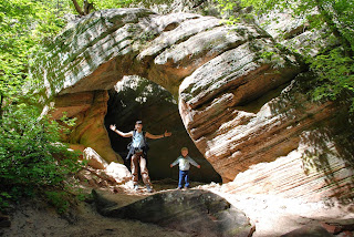
We finally decided that we would visit Bryce Canyon first and explore the northern side of Grand Staircase-Escalante National Monument, since Zion was a bit closer to southern Arizona. On April 24, we drove north to a Forest Service campground near Bryce Canyon in preparation for our visit. That day, we drove part of Utah's Scenic Byway 12, voted the most scenic drive in the U.S. and third most scenic drive in the world (by who? No idea... it's just what they told us at the visitor center). We stopped at neat trail called Mossy Cave, surrounded by colorful hoodoos, that led to a waterfall and moist rocky alcove. We also visited Kodachrome Basin State Park, a name given to the area by a National Geographic Society expedition in 1948 due to the numerous variations in colors. The park is known for its tall rock spires, called sedimentary pipes, that rise up like massive lone chimneys from the landscape. We hiked several trails that wound through and above the fascinating formations.
.JPG) |
| Snow again? Dixie National Forest |
On the morning of April 25, our plans changed again. The temperatures near Bryce Canyon dropped and we woke up to yet ANOTHER day covered in snow with a freezing windchill. We were sick of being cold! Bryce is at a much higher elevation than Zion. After looking at the forecast, we saw that the Bryce would be dropping down to the 30s at night for the next several days, while Zion would be in the 80s during the day and 50s at night. It was time to be flexible. Sunshine and I looked at each other and said, "Let's go to Zion!"
We actually had a "preview trip" of Zion on April 23, when we drove through the eastern entrance to check out that side of the park. Our trip led us through a tunnel (that we didn't know existed) to the western part of the park, and we had a chance to visit the visitor center, hike a couple of trails, and figure out how to best get one of those coveted "first come-first serve" campsites. We knew we would have to get there around 8 a.m. in the morning to have a chance at getting a campsite. So, on April 25, we decided to drive to the city of Hurricane, which was conveniently located just 20 minutes from the west entrance of Zion AND had a Walmart where we could stay in the parking lot for free. Sunshine chose a shortcut scenic route to get from our campsite to
Hurricane... Utah Highway 14, or the Markagunt High Plateau Scenic
Byway. Unfortunately, what our map
didn't show, was that the byway climbs 9,900 feet and a major snowstorm on top of the mountain was causing white-out conditions. We drove very carefully and very slowly, inching our way over the top of the summit. The "shortcut" took much longer than expected! When we finally arrived in Hurricane that evening, we were pleased to find the Walmart very accommodating... free parking, 24-hour restrooms, and all of the supplies you ever would need. Hey, it's hardly camping, but we HAD to try it at least once during our trip!
.JPG) |
| Staying at Walmart in Hurricane, Utah. |
ZION NATIONAL PARK
The next morning, April 26, we raced over to the west entrance of Zion, and as people were waking up in the first come-first serve South Campground, we were waiting like vultures to snatch up their campsite. We actually found one that was empty, except for two full bundles of firewood. Score! With the cost of firewood, that was like an entire day's camping fee. We spread out over the large campsite and made ourselves at home for the next five days.
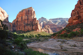
.JPG) |
| Angel's Landing Trail, Zion |
Zion was incredible, defying the imagination. Massive stone monuments of all different shapes and colors towered above the campground and roads. Red, orange, pink, and white rock layers changed hues throughout the day as the sun rose and set. Brilliant flowers bloomed on the rocky slopes. The bubbling Virgin River (more of a creek) that ran through the canyon was an oasis in the desert park, nurturing a corridor of shady cottonwoods that were blooming, the sweet scent wafting through the campground. Walden loved playing in the water and in the sand along the banks.
The only issue? People, people, people. The park was incredibly busy, with long lines of noisy vehicles filling up the parking lots by 10 a.m., some trails so clogged that you were nearly tripping over other hikers, buses of international tourists being dropped off at every scenic overlook. This took some getting used to! We had been visiting some pretty remote areas for the past few weeks. Fortunately, the main canyon was only accessible by a shuttle bus, which
conveniently started at the visitor center near our campground. Therefore, we never actually needed to use our vehicle once it was parked at the campsite.
Here are some highlights:
.JPG) |
Holding onto a chain on the
Angel's Landing Trail |
- Watchman Trail (April 23, 2.7 miles, near the campground): The trail goes up (like nearly every trail at Zion!) to a lookout point. The flowers were magnificent along the trail... cactus pink, red Indian Paintbrush, white, yellow.
- Angel's Landing Trail (April 27, 4 miles): This is one of the most incredible trails in the national parks. It ascends nearly 1,500 feet in 2.5 miles. The last portion is not really a trail, but rather an extremely narrow climb to the top of a massive rock formation in the middle of the canyon, with steep drop-offs on both sides and only a chain to hold onto. My original plan was to carry Walden all the way to the top in the child backpack. We had been practicing for days to SIT VERY STILL so there wouldn't be a sudden shift of weight as I was crossing a narrow section. This trail was extremely busy, clogged with what appeared to be European international visitors who were practically running us over to get to the top. The trail ascends a nearly vertical wall that looks impossible to scale, but numerous switchbacks were carved into the side. Walden calls them "wiggle waggles." We made it all the way up the trail to Scout Lookout (1,000 feet), the last stop before the exposed climbing. We had some discussions (Sunshine does have a fear of heights and we have that darn parental responsibility to keep our son safe), but we decided to try the climb and turn around if it seemed too dangerous. After some encounters with slippery rock surfaces, clinging hard to the chain above steep drop-offs, dealing with the pressure of overly eager hikers behind us, and hearing a man say he would never do this trail with a kid, we decided that turning around was the most responsible thing to do. And as parents, you sometimes have to make those hard decisions. So actually reaching Angel's Landing will have to wait for another trip... maybe when Walden is 15?
.JPG) |
| View of Angel's Landing from below |
.JPG) |
| Lower Emerald Pools trail |
- Emerald Pools Trail (April 27, 2.6 miles): Water is what defines Zion National Park. It carved the canyons and rock formations, and is of course essential for life to survive. The Emerald Pools trail leads to pools of water that are formed by the slow dripping of seepage in the sandstone. Hanging gardens form where water comes out of the rock, creating beautiful, green, cool grottoes in contrast to the hot desert canyons. The Upper Pool, where the water actually comes out of the rock wall, was a heck of hot climb, especially after doing the Angel's Landing trail earlier in the day. The quietness surrounding the pool was the most fascinating... there were over 20 people sitting around the pool, but it was almost a quiet reverence for the site, like sitting in a church. Of course, Walden broke this as he tested the walls for echoes and ran to touch the water. The Lower Pool was surrounded by sandstone ledges with soft waterfalls streaming down from the upper pools. The trail actually went behind the waterfall providing a refreshing mist.
- Zion Lodge and ice cream! (April 27): Built in 1926, the lodge burned in 1966 and was rebuilt. Walden would tell you that his favorite part of the Zion trip was getting to eat ice cream at the Zion Lodge after our big hike!
.JPG) |
| On the edge of the Hidden Canyon Trail |
- Hidden Canyon Trail (April 28, 3.2 miles): Our favorite trail in Zion was the Hidden Canyon Trail. It was a crazy steep climb up, like the Angel's Landing Trail, but without the hordes of visitors... very refreshing. A series of switchbacks with spectacular views led to some steep, narrow paths carved into the edge of the cliffs, with only chains to hold onto. Unlike Angel's Landing, I did feel safe walking the paths with Walden on my back... although we did practice our SIT STILL AND BE QUIET skill quite a bit! The trail ends at the mouth of an amazing hanging slot canyon. Then, we were on our own! We climbed over rocks and logs into the canyon itself, where massive vertical walls created a towering hallway. We discovered intricate patterns that water had carved into sandstone. We played hide-and-seek around a free-standing rock arch. We climbed on boulders and played in the sand. About a half-mile into the canyon, large rock boulders blocked the way, so we ate lunch there, watch some other people scrambling, and slowly walked out again. It was an incredible opportunity to simply explore and discover... this is what Walden loves best.
.JPG) |
| Exploring the Hidden Canyon |
.JPG) |
| Walden shows off his Junior Ranger badge |
- Junior Ranger badge (April 29): When we arrived in Zion at the visitor center, the ranger gave Walden a Junior Ranger booklet. So we spent several days completing the different activities, which included watching the orientation film, doing a nature scavenger hunt, and seeing what people in a picture were doing wrong (Walden's favorite... a man taking rocks from the park. This makes it very difficult when Mom and Dad want to add to their collections!) On April 29, we brought the book back to the visitor center, and Walden became an official Zion Junior Ranger with a plastic badge. He was so proud of that badge, that he showed it to anyone who would look. Neat program!
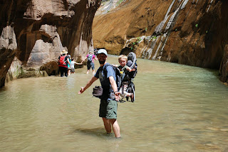.JPG) |
| Hiking The Narrows |
- The Narrows (April 29, 2.5 miles): The last trail that we hiked in Zion was the Riverside Walk, which follows the Virgin River to the north. Here, the geology begins to change to harder rock, and the canyon walls get narrower and narrower. At the end of the trail, you can choose to continue walking into the canyon, but the walls are so narrow, there is no trail. You have to walk in the water instead. Again, this is one of the most popular hikes in Zion, so the crowds were there again. Sunshine decided to rest her toe at the end of the trail, which had an injury, but Walden and I continued on. Laced up with full hiking boots (required due to the numerous rocks under the stream and the swift current) and loaded up with Walden in the backpack, we plunged into the cold stream (about 45 degrees?) and began hiking up the canyon. The hike was spectacular. Steep walls on both sides, waterfalls running over the edge from rock seeps, caves and grottoes carved by the stream. By careful route planning, I only got the bottom of my shorts wet (though we saw several other people plunge in above their waists). We hiked about a quarter-mile, found a small sandy area, and Walden got out and played in the water and rocks.
In the end, we were amazed at the variety of opportunities that Zion offered. Some parks really focus on one major asset, like the hoodoos of Bryce Canyon. But at Zion, there was so much more than just the rock formations... walking and playing in streams, dripping overhangs, pools, and waterfalls, hidden canyons to explore, museums, scenic drives, tunnels, wildflowers, crazy exposed trails. We were fortunate to be able to spend so much time at this amazing place.
BRYCE CANYON NATIONAL PARK
On April 30, we left Zion National Park to visit Bryce Canyon, which, according to the weather forecast, would be in the 70s during the day and 40s at night... much better than the week before! One of the reasons that we had driven to the west entrance of Zion earlier was because of the tunnel on the Zion-Mount Carmel Highway. Built in 1930 to open Zion to tourism east of the park, the tunnel was now too small to accommodate most RVs and trailers. If you're too large, you have to pay an extra $15 for an escort (essentially closing down the tunnel to oncoming traffic). And we're cheap! So we avoided the tunnel while hauling our Burro. However, after checking the dimensions, we discovered that our little Burro was small enough to fit in the tunnel without having to pay the fee! We ended up saving a huge amount of time by driving our Burro through the tunnel on our way to Bryce... although, we all scrunched our shoulders together to get a little smaller while driving through the tunnel.
.jpg) |
| Bryce amphitheater at sunset |
Being so near to Zion, it seems like Bryce Canyon would be a similar kind of experience. But it's like a completely different world. The elevation is much higher, and therefore the weather is cooler. The park is long and narrow, focusing specifically on the unique geology of the area. The visitor center is smaller. And it just feels different... it's less crowded, less rushed, more peaceful, more intimate.
.JPG) |
| Hoodoos along the Navajo Loop Trail |
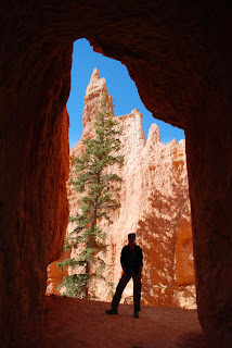
The landscape itself is absolutely breathtaking. When you look over the edge of the lookout for the first time, "wow" is the only word that describe it. The "canyons" (actually amphitheaters) are studded by thousands of colorful rock spires, called "hoodoos", that form a forest of rocky trees. The tops of the spires are like snowflakes, each with its own unique shape and personality. The deep colors of red, orange, pink, and white are horizontal bands that you can see replicated through all of the rocks from one side of the amphitheater to the other. Photos don't come close to showing how vast the carved area truly is, and how insignificant you feel looking down.
.JPG) |
| A dusty boy |
We had our choice of several campsites in two different campgrounds. We
chose one in the Sunset Campground, where we stayed for 4 days. This provided easy access to the
main viewing points and trails. One thing we discovered quickly, Bryce Canyon is DUSTY. The gravel roads in the campground are dusty. The campsites themselves are dusty. And, by default, Walden was COVERED in dust from head-to-toe almost instantly. It sure is fun digging in dust, throwing it into the air to watch the wind carry it, and, of course, putting it on your head.
Here are some highlights of our Bryce Canyon adventure:
.JPG) |
| Selfie with a hoodoo, Fairyland Trail |
- Fairyland Trail (May 1, 9 miles): Sunshine and Walden were nice enough to give me a solo hiking day! After hiking with months with Walden on my back, a strenuous 9-mile hike through the canyons felt amazingly easy. Fairyland Canyon is a smaller and more intimate canyon just north of the massive Bryce Amphitheater. The hoodoos are younger and have brilliant colors. The trail leads into the Bryce Canyon Wilderness Area, much less popular than the main Bryce Amphitheater, and I was happy to see only a few people on the hike. It's a totally different experience to hike among the hoodoos rather than just look at them from above. They tower above you in all sorts of crumbling shapes. I enjoyed being able to actually touch them; the sensory experience created a deeper personal connection for me. The trail descends into Fairyland Canyon, then up onto a ridge with amazing views, then back down into Campbell Canyon. The hoodoos here were much different. They are older, and therefore weathered down to clumps rather than spires, a "hoodoo graveyard." The trail provides view of the Tower Bridge formation, with two rock bridges, and then ascends back up the canyon past blindingly white walls (called the China Wall) and spires. When I got to the top, I treated myself to a slice of pizza from the General Store... I know, roughing it.
.JPG) |
Sunset at Inspiration
Point |
- Inspiration Point sunset (May 1): That evening, we hiked to Inspiration Point, a lookout high above the Bryce Amphitheater, and another good uphill hike from our campsite (why are all of the trails uphill?). The setting sun created a wonderland of deep colors and shadows. The hike was spectacular along the rim of the canyon. Of course, Walden wanted to get out of the backpack at every overlook and dangerous cliff. So when we reached Inspiration Point, we let him out to explore... while watching him carefully every second ("Stop climbing the fence!", "Stay away from the edge!", "Hold my hand on the steep part!"). He loved leading the way down the steep hill trail, making funny noises as he bounced down running. We watched the full moon rise above the surreal landscape.
.JPG) |
| Sunshine on Peekaboo Trail |
- Navajo/Peekaboo/Queens Garden Trails (May 2, 6 miles): The main trails at Bryce Canyon weave through the hoodoos of the massive Bryce Amphitheater. These trails are also the most popular, so we did have to contend with the crowds again. We started at Sunset Point and descended steeply on a series of switchbacks on the Navajo Loop Trail. Quickly, hoodoos of fanciful shapes were towering over our heads, including the iconic Thor's Hammer. We continued descending into a narrow canyon where, amazingly, Ponderosa pine trees survived in the shaded environment. At the bottom, we saw Twin Bridges, two natural rock bridges eroded from the canyon material, and continued onto the Peekaboo Trail. This steep up-and-down 3-mile loop seemed to have a surprise around every corner... tunnels, colorful hoodoos, the Wall of Windows (large holes eroded out of the cliff face), a horse tour, and incredible views. After eating lunch, we took the Queens Garden Trail to ascend out of the canyon again. The Queens Garden is an area filled with especially colorful hoodoos (pinks, purples, whites) that seem to grow out of the ground. One was supposed to look like Queen Victoria, but Walden and I couldn't see the resemblance. We continued the steep climb out of the amphitheater, traveling through more tunnels in the rock, to reach Sunrise Point at the top. And Walden, for being such a good hiker, got his favorite treat in the world... another ice cream cone.
.JPG) |
| Queen's Garden |
.JPG) |
| Earning our "I Hiked the Hoodoos" pins |
- Hike the Hoodoos pins (May 2): Scattered throughout Bryce Canyon are small interpretive panels called "Hike the Hoodoos." This is part of a fitness challenge. If you visit three of these signs and make a rubbing (or take a photo of yourself with the sign), you get an award. In total, we actually visited 6 of the signs with all of our hiking. Walden showed our photos to the ranger at the visitor center, and we each received a really nice metal pin that said, "I Hiked the Hoodoos." What a neat idea!
UTAH'S SCENIC BYWAY 12
.JPG) |
| Escalante Interagency Visitor Center |
On May 3, we left the campground in Bryce Canyon, moved the Burro to a parking area outside the park, and finally got to travel the rest of Scenic Byway 12. Calling it the most scenic byway in the U.S. might be a stretch (considering "scenic" is a subjective experience), but the scenery and history is incredible. From Powell Point, a pink cliff that rises above gray badlands, to ancient Pueblo structures hidden in rocky alcoves, from riding on a large lizard sculpture (visitor center in Escalante), to discovering the Mormon "Hole-in-the-Rock" expedition (a 6-week effort to blaze a road that turned into a 6-month battle against the elements), we had so much fun exploring. Some of the highlights include:
.JPG) |
| Lower Calf Creek Falls |
- Viewing how the road meanders over the vast Escalante Canyons and colorful slickrock; it was built by the CCC and nicknamed the Million Dollar Highway.
- Hiking to Lower Calf Creek Falls in Grand Staircase-Escalante National Monument (6 miles). A storm was brewing and it was incredible walking through the canyon listening to the deep rumbles of thunder echoing off the walls. It also made us walk faster! Fortunately, we only had a few sprinkles of rain. The wispy 126-foot waterfall pouring through a slot in the canyon wall was amazing. Moss and algae made the wall glow green behind.
- Driving The Hogback. This famous portion of the byway curves along the very top of a narrow slickrock ridge that drops into canyons on both sides.
- Camping for FREE in the Dixie National Forest just outside Red Canyon. The dispersed campsite was better than many that we had paid for, with great views of the full moon rising.
- Hiking through Red Canyon (2 miles). One of the most photographed areas in Utah, the Red Canyon in the Dixie National Forest was developed as a gateway to Bryce Canyon. The scenic byway travels through two tunnels constructed in 1925. The canyon itself, easily accessible from the road, is covered with incredible red sandstone spires and formations.
.JPG) |
| Driving through a tunnel in Red Canyon |
Southern Utah was a spectacular part of our trip and definitely a place that we will return in the future. Now, on to southern Arizona to visit Grammie and Grandpa!


.JPG)

.jpg)


.JPG)
.JPG)
.JPG)
.JPG)
.JPG)
.JPG)
.JPG)
.JPG)
.JPG)
.JPG)
.JPG)
.JPG)
.JPG)
.JPG)
.jpg)
.JPG)
.JPG)
.JPG)
.JPG)
.JPG)
.JPG)
.JPG)
.JPG)
.JPG)
.JPG)